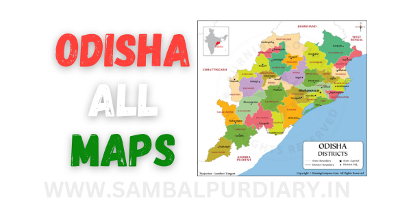
Odisha Map With District, Panchayat And Village
odisha map with districts, village panchyat odisha political map geography roads and hills
Maps are essential for understanding and navigating a region's physical, political, and cultural characteristics. In the case of Odisha, a compelling state on India's eastern coast, several maps give useful information on its districts, topography, infrastructure, and attractions. In this post, we will look at many sorts of maps that display the various features of Odisha, allowing both inhabitants and tourists to easily explore this lively state.
Odisha State Map
The Odisha State Map depicts the state's boundaries as well as its location within India. This detailed map depicts the major cities, towns, rivers, and neighbouring states, providing a more thorough view of Odisha's physical position and interaction with its surrounds.
Odisha District Map
The Odisha District Map focuses on the state's administrative divisions, highlighting the state's different districts. Each district is depicted with its boundaries clearly delineated, allowing visitors to comprehend Odisha's geographical divisions and spatial organisation.
Detailed Odisha Map
A comprehensive Odisha Map extends beyond the state's surface-level picture. It covers technical features such as highways, trains, bodies of water, and landmarks, offering a thorough picture of the state's terrain. This map allows users to explore Odisha's nooks and crannies, making journey planning and navigating easier.
Odisha Political Map
The Odisha Political Map focuses on the state's political landscape. It displays the distribution of political power in Odisha by highlighting the borders of each constituency. This map assists in understanding the state's political processes and is a useful resource during elections and governance study.
Odisha Geographical Map
An Odisha Geographical Map depicts the state's natural characteristics in great detail. It depicts the varied geography, which includes mountains, plateaus, plains, and coastal locations. This map aids in the study of landforms, the identification of biological hotspots, and the appreciation of Odisha's great geographical variety.
Odisha Outline Map
The Odisha Outline Map depicts the state's boundaries in a basic manner, with no unnecessary information. It is a significant instructional tool, allowing students and scholars to precisely analyse and categorise various regions of Odisha. This map promotes learning by allowing for a concentrated exploration of the state's outline.
Odisha Road Map
The Odisha Road Map is a must-have for road trippers exploring the state. It highlights Odisha's large network of motorways, major roads, and local routes, assisting travellers in navigating the state's towns and cities. This map also shows rest stops, gas stations, and prominent sites, assuring a pleasant and memorable ride.
Odisha Tourist Map
The Odisha Tourist Map was created primarily for visitors looking to discover the state's attractions. It features well-known tourist destinations, heritage sites, national parks, wildlife refuges, and cultural icons. This map is a wonderful resource for travellers, supporting them in organising itineraries and making the most of their Odisha experience.
Odisha City Map
The Odisha City Map focuses on specific cities around the state, offering a comprehensive overview of their streets, neighbourhoods, and major attractions. This map assists residents and tourists in easily navigating metropolitan areas, locating specific addresses, and discovering local facilities such as restaurants, hotels, and shopping centres.
Odisha Map with Districts
Odisha Map with Districts contains a detailed state map with well defined district borders. Users may use this map to comprehend the spatial distribution of districts within the state, allowing them to better understand administrative divisions and regional linkages.
Conclusion: Maps are useful tools for deciphering Odisha's subtle nuances. The many maps offered provide a thorough insight of Odisha's geography, culture, and infrastructure, whether it's exploring its different districts, comprehending its political scene, navigating its cities, or organising a great vacation. Individuals may use these detailed maps to discover Odisha's hidden jewels, dig into its rich legacy, and embark on fascinating trips inside this enchanting state.

